Since there is no current technology to show how openly fractured the bedrock is in a particular spot, wells are dug in locations that are the best guess by the drilling company while following the DEM regulations regarding the required distance from nearby ISDS leach fields for water quality from recharge effects. Usually, in a deep bedrock aquifer, the drilling company will go deep enough to assure the well delivers at least 5 gallons per minute of flow to the home.
Throughout the Shores there are wells that produce water at a variety of depths, from as little as 30 feet to as much as 400 feet. Many of the shallow wells were dug at the time the Shores was first developed as primarily a summer cottage project and water supply was not a year round concern.
In 1997 a water quality study was done by a URI graduate student Anne Veeger, that developed a considerable amount of data about water quality and included well depth information where available. Check out this chart of several well locations with depths.
The Veeger project led to the eventual regulations we live under now titled the Onsite Wastewater Management Program which helps to protect the quality of the ISDS recharge and promotes more responsible care and new development oversight.
In 2003 a URI study was released titled Jamestown Source Water Assessment and Wastewater Needs Analysis that detailed the status of the full North Island aquifer that included the Shores as an important stake holder in the ground water supply.
In looking at the report again and checking some numbers... here are a few estimates and likely outcomes etc. which we will update as needed when newer relative data is available.
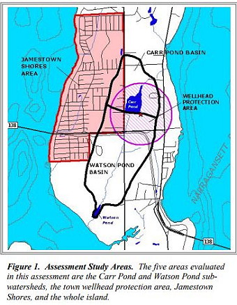
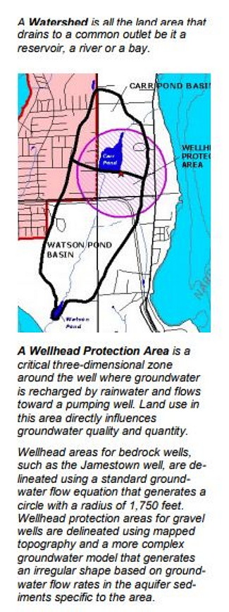
First... How Large is the Shores Aquifer and how much water does it hold?
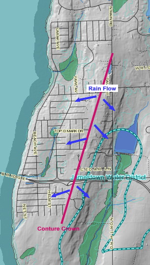
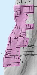 The area used for the computations is just the
perimeter of the Shores as shown using Google maps data. With this
contour view we can see that there are slopes and adjoining areas that
likely contribute to the overall volume available... like to the North toward West
Reach and the South towards Watson's Farm. However, to deal with the
property that we identify as the Shores development, only the perimeter of
the developed properties was used.
The total area came out to 32,000,000 square feet (roughly 3,300 feet
wide E to W, and 9,800 feet long N to S).
The area used for the computations is just the
perimeter of the Shores as shown using Google maps data. With this
contour view we can see that there are slopes and adjoining areas that
likely contribute to the overall volume available... like to the North toward West
Reach and the South towards Watson's Farm. However, to deal with the
property that we identify as the Shores development, only the perimeter of
the developed properties was used.
The total area came out to 32,000,000 square feet (roughly 3,300 feet
wide E to W, and 9,800 feet long N to S). Next we need to know the depth of the bedrock that holds fresh water. A fact sheet from Rhode Island Department of Health uses a number of... 500 feet deep at the center of the island and gradually gets lower as it moves toward the coast to about 25 feet.
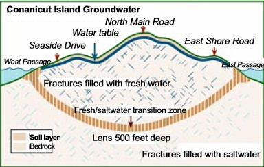
It's important to note that the lower bedrock fractures contain saltwater and the freshwater in the fractures floats on top. As the fresh water supply gets lower it's mass weight decreases and the saltwater rises higher and will intrude into the wells of those along the shore as has happened in the past on Seaside Drive. (See the Fact Sheet insert on the Groundwater Lens to the right)
Although, using a simple calculation of an East-West slice of the bedrock, that is 3,300 feet wide and 500 feet deep and then dividing it by 2 (assuming that the bottom would diminish toward the shore in a straight line) we get an average depth of 250 feet. However, to stay on the conservative side of this estimate we used an average depth of 175 feet which gave us 5,600,000,000 cubic feet of aquifer. (yes that's billions). Next, we need to calculate how much water there can be in our total bedrock mass.
Of all the research data we reviewed on the internet, the most conservative was in a study done in 2016 for San Joaquin Valley, California. Their report claims... "Groundwater stored in a fractured rock aquifer is much less than 2% of the rock volume."
In one example, they actually used a much lower amount in their computations of just .03 gallons per cubic foot, because their study sample had cracks of only 1mm in width. So, going with that number to be super conservative, our aquifer would hold... at the minimum... 168,000,000 gallons of water. It will be quite a lot more if the typical bedrock crack is larger than a popsicle stick, which is much smaller then those found in the Carboniferous Metasedimentary bedrock of Northern Jamestown.
To determine how that puts us in the supply equation... we used a number of 877 households with the average use per household (according to the above URI studies) of 160 gallons per day... which comes out to 140,000 gallons for the entire Shores... per day.
Now, because the Shores relies on ISDS for wastewater treatment and not a centralized Sewer Treatment system, the calculation of available daily water use from the aquifer has a recharge volume... going back into the supply. The conservative estimates total 120 gallons per day - per household... resulting in net daily use total of just 34,760 gallons throughout the entire Shores.
So... if there was no rain for a long, long time, it would take a little more than 13 years to use all the water in the aquifer. Of course, it will rain and regularly replenish the Shores bedrock, so chances are very good that our 877 households will never run out of water. However, based on the depth of a well and the amount and size of the fractures it encounters some could run dry sooner. The aquifer as a whole is not a giant container of water that every well draws from, bedrock fractures are complex, obscure and illusive.
In fact, the Source Water Assessment mentioned above, claims there is an average of 223,000,000 gallons of annual recharge for the Shores from rain alone. Quite a bit more than we calculated for ISDS recharge at 36,000,000 gallons per year.
So our overall layperson's conclusion of the reviewed data shows... there is no need to panic about supply just yet. Chances are that those who are experiencing low flow will find their solution by drilling a deeper well, however in certain locations like along the shore and lower lying areas, there are risks that over pumping by those on higher ground could make deeper drilling futile for them.
Now this doesn't mean we don't have to be involved with conservation thinking and yes... it is a bit unsettling to see people watering their lawns during dry conditions. People with new lawns and those with steep slopes need to water. Hopefully those who are simply interested in appearance will find it better to hold off during a dry summer. It's a good neighbor practice that the longer we go without a rain event... cutting back on outdoor water use should increase where possible.
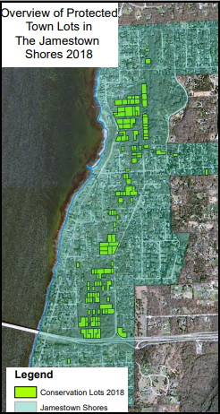
As many may know, there have been efforts to protect our aquifer supply with the Town acquiring vacant unbuildable lots that provide recharge (@ 100 to date), mostly in the lower wetlands. Unfortunately many of the lots are not managed forests so the trees use up a lot more water than we normally pay attention to.
Estimates are that a full grown acre of forest can absorb up to 1 million gallons a year from an aquifer. A single 30 foot mature tree can use 100+ gallons per day, which is four times more than the average household with an ISDS.
In the URI Source Water Assessment report, the Shores is listed as having 765 Acres, for the study area. It also shows the Forest area as 15% totaling 115 Acres.
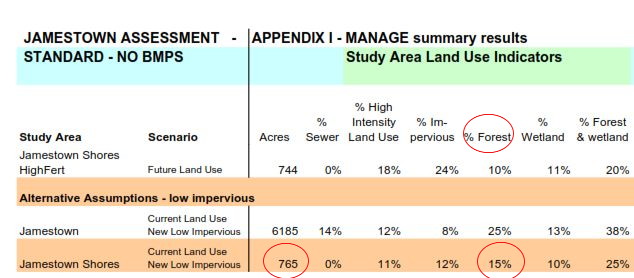
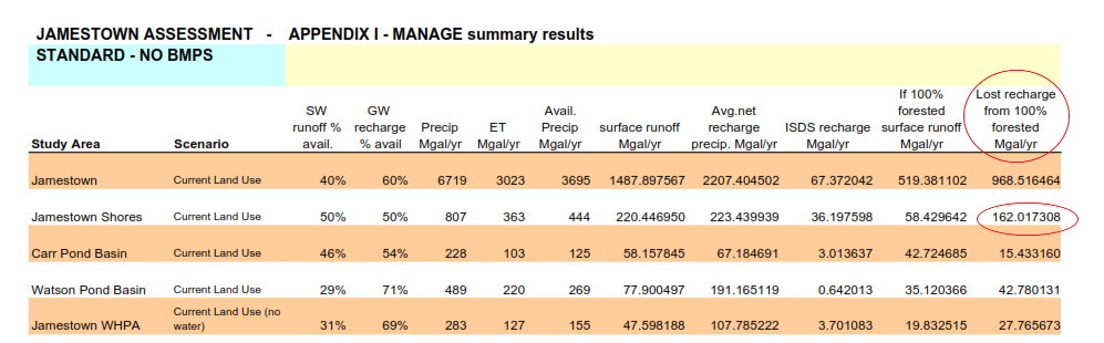
Their estimates of the "Lost Recharge" from 100% forested in Million of Gallons per year of 160,000,000 which is actually more than one million gallons per acre.
Homeowners in areas of concern might want to take an inventory of the trees on their property and remove the very largest and replace with newer saplings.
Management is an important issue for those undeveloped lots acquired for recharge and could provide an extra level of supply and peace of mind. We will be urging the Town consider suggestions detailed in our Forest Management Review that will allow for a maximum recharge from undeveloped lots and minimize unnecessary groundwater loss from overgrown forests.
New findings from other recharge methods used to preserve groundwater!
In researching how other areas are handling water recharge we came upon a method that we may already be taking advantage of... subsurface dams.
Although they have many different designs depending on the geology, basically they are a way to slow down and/or preserve groundwater that is flowing into streams or wet lands. This is especially needed where the topography is hilly and underground flow rates are rapid.
Much of the Shores soils/till have slow permeability and make it more difficult for rainwater to reach the bedrock aquifer which is the reason for our designation as the High Ground Water District.
Do to the hilly terrain throughout the neighborhoods, much of the groundwater moves through the topsoil/till and either settles in the wetlands or goes out to the bay. Fortunately, enough does get through to the bedrock to give us ample supply for our wells.
After studying how subsurface dams are used and how they assist in managing underground water flow, an unintended benefit of the buildup of homes in the Shores may be the recharging effect of having several hundred "micro dams" helping out because of their... foundations.

When we look at the contours, it's clear the that the groundwater is flowing in several directions and obviously being interrupted by the presence of building foundations.
Below, the normal water flow through the top soil (till) and the hard pan soil shows how it works. Without any foundation the penetration into the bedrock is more difficult because the groundwater takes the path of least resistance with the help of gravity. Placing a home into the picture interrupts the flow and creates a damming effect that allows for the slowing down and buildup of the groundwater, giving it more time to infiltration into the bedrock aquifer.
So perhaps now, when we see an overgrown lot being cleared and the foundation poured for a new home and having the understanding that the removed trees will no longer be competing with us for the rainwater and the foundation will help with recharging the aquifer, we can feel better about the change in the neighborhood.
*** Important Text from the Source Water Assessment and Wastewater Needs Analysis...
3.2 Jamestown’s Groundwater
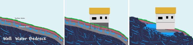
All fresh water on Conanicut Island comes from precipitation.
Rainwater seeps into the ground, replenishing streams, reservoirs and
groundwater. Groundwater held in bedrock fractures is the primary
source of drinking water. But the Island’s bedrock aquifer has limited
yield and over pumping can draw salt water into wells. The amount of
freshwater available and its quality is directly related to land use
activities in the watershed or recharge area, including the quality of
effluent discharged from septic systems and the amount of recharge
available to dilute infiltrating pollutants and maintain a balance with
surface waters. Because surface waters and groundwater are closely
connected, changes in water flow and pollutant inputs affect both
resources.
Getting water from a rock
The Island core is fractured bedrock, overlain by a thin layer of soil
and sediments up to 30 feet thick. A compacted “hardpan” layer 2-4
feet deep extends throughout much of the Island, restricting
downward water flow. This dense layer, combined with fine soils
that transmit water slowly and shallow bedrock in some areas creates
seasonal high water table throughout much of the island. Infiltrating
rainwater tends to flow along the hardpan layer and emerge in
wetlands and other surface waters. Water infiltrating deeper fills
cracks in the underlying bedrock where it is stored and moves more
slowly toward surface waters and coastal shoreline. Water held in
these cracks forms a “bedrock aquifer”.
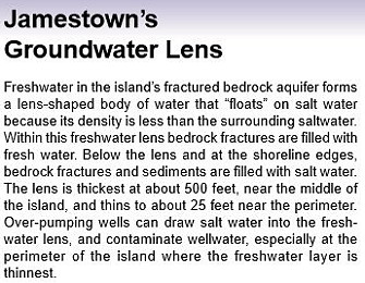
Jamestown’s Groundwater Lens
Freshwater in the Island’s fractured bedrock aquifer forms a lens
shaped body of water that “floats” on saltwater because its density is
less than the surrounding saltwater. Within this freshwater lens
bedrock fractures are filled with fresh water. Below the lens and at
the shoreline edges, bedrock fractures and sediments are filled with
salt water. The lens is thickest, about 500 feet, near the middle of the
island and thins to only a few tens of feet near the perimeter. Over
pumping wells can draw saltwater into the freshwater lens,
especially at the perimeter of the Island where the freshwater layer is thinnest.
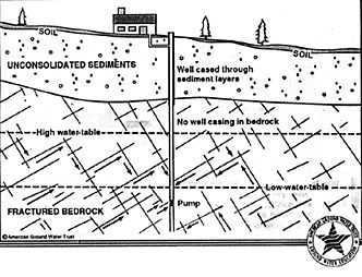
Predicting groundwater yield
The amount of water available from bedrock wells depends on the
number and width of fracture openings and is difficult to predict. The
limited amount of water held in small fractures results in relatively
low yields and high drawdown. For example, a pumping rate of only
at the perimeter of the Island where the freshwater layer is thinnest.
five gallons per minute is typical of residential wells in bedrock. A
well pumping at this rate would “drawdown” or lower the water table
in the vicinity of the pumping well approximately 70 feet, and 100
feet or more in wells with lower yields. The amount of groundwater
available is based on the number and size of bedrock fractures.
Because this is difficult to predict, it is almost impossible to forecast
how much water a new well will yield. However, deeper bedrock
wells generally have a larger reservoir, potentially intersecting more
water-filled fractures with greater depth. Since each well creates it’s
own draw down effect, wells clustered together on small lots are more
likely to have overlapping draw down areas, resulting in lower water
table collectively. Over pumping wells can draw saltwater into the
freshwater lens, especially at the perimeter of the Island where the
freshwater layer is thinnest. When building on an undeveloped lot it is
wise to first drill a well and conduct a pump test to determine if the
yield is adequate for household needs. (Adapted from Veeger et.al.,
199).
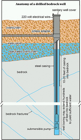
Using a drill rig, well drillers begin by drilling a hole about 9" in diameter through the overburden sediment overlying bedrock. When bedrock is encountered, drilling continues until competent bedrock is reached, generally between 10 and 20 feet. Steel casing is then installed in this hole and sealed to the bedrock. This casing seals the well from potential contaminants from surface infiltration. Drilling continues through the bottom of the casing until water-bearing fractures are encountered. Ground water fills the well to a level based on local geologic conditions. A submersible pump is then lowered into the well to bring water to the surface. The well casing protrudes out of the ground surface and is covered with a sanitary cap to prevent contamination. The water in the well above the pump is in storage and is available to be pumped out when needed. A bedrock well with low yield can still provide enough water for household use if the well boring itself holds enough water in storage to meet periods of peak demand
Shores Contour View with Rain Flow Direction